
map:


info:Kentucky became the _______ state of the United States on June 1, 1792. Frankfort is the cap.
- Capital City: Frankfort
- City Guides: Kentucky City Guides
- Location: 38.190N, 84.865W
- Capital Tour: Capitol Tour
- 50states School Directory: Find your school!
- Admission to Statehood: June 1, 1792
- Ancestry and Genealogy: Kentucky State Database
- Area: 40411 sq.mi., 37th Land 39732 sq.mi., 36th Water 679 sq.mi., 38th
- Area Codes: 270 - 502 - 606 - 859
- Biographies: Famous Kentuckians
- Bird: Cardinal 50states List
- Border States: Regional List Illinois Indiana Missouri Ohio Tennessee Virginia West Virginia
- Cam World: Live Web Cams
- City Guides: Kentucky City Guides
- Classified Ads: Shop50states Classifieds
- Climate: Kentucky
- Colleges, Universities: Kentucky Colleges, Kentucky Business Schools, Kentucky Art Schools
- Community and Technical Colleges: Kentucky Community Colleges
- Community Pages: 50states List
- Constitution: 15th State
- County Profile: County Map 120 Counties
- Courts: Judicial System
- Current Events: Kentucky News Headlines
- Department of: Education Certification
- Driving: DDL
- Economy:
- Agriculture: Horses, cattle, tobacco, dairy products, hogs, soybeans, corn.
- Industry: Transportation equipment, chemical products, electric equipment, machinery, food processing, tobacco products, coal, tourism.
- Editorial Cartoons: Cartoonists Index
- Fast Facts: 50states List
- Flag:
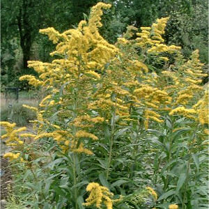
Placed on a navy blue field is the seal and words "Commonwealth of Kentucky". The two friends shaking hands, a pioneer and a statesman, represent all the people. They are acting out the meaning of Kentucky's motto: "United We Stand; Divided We Fall". Sprays of the state flower {goldenrod} extend in a half circle around the picture. Flag adopted 1918 amended in 1928 & 1962. Get this Flag - Flower: Goldenrod Solidago altissima
- Genealogical Resources: Cyndi's List Kygenweb Historical Societies
- Geographic Center: Marion, 3 miles northnorthwest of Lebanon
- Governor: Office of Governor
- Highest Point: Black Mountain; 4,145 feet, 27th
- Highway Markers: Kentucky Resource Manual
- History: Historical Civil War
- Internet Service Providers: Kentucky
- Largest Cities: Louisville Lexington - Fayette Owensboro Bowling Green Covington Hopkinsville Frankfort Henderson Richmond Jeffersontown
- Library: Kentucky Kentucky Libraries
- License Plates: Kentucky
- Local Resources: Kentucky Courts Kentucky Fire Departments Kentucky Counseling Services Kentucky Police Departments Kentucky Government Offices
- Lottery: Kentucky Lottery
- Lowest Point: Mississippi River; 257 feet, 32nd
- Maps: Rand McNally
DMOZ Blank Outline Map 50states List
- Media: Radio TV
- Motto: United we stand, divided we fall
- Museums: The Virtual Library
- National Forest: Kentucky
- Newspapers: Kentucky
- Nickname: Bluegrass State
- Nursing Schools: Kentucky
- Origin of state's name: Based on the Iroquois Indian word "Ken-tah-ten," meaning "land of tomorrow"
- Pen Pals: Penpalworld.com
- Permanent Residents: Find A Grave
- Population: Quick facts 4,041,769; 25th, 12/00
- Presidental Birthplace:
- Abraham Lincoln, 1861-1865 {16th}
- Born: February 12, 1809, in Hardin (now Larue) County, Kentucky
- Public Records: Kentucky
- Real Estate: Kentucky Real Estate
- Representatives:
- US House: 110th Congress
- US Senate: 110th Congress
- Kentucky House: Members
- Kentucky Senate: Members
- Road Side America: Kentucky
- School Directory: Kentucky Schools
Public Schools Private Schools
- Soil: Kentucky - Crider
- Song: My Old Kentucky Home 50states List Sheet Music
- words and music by: Stephen C. Foster
- Sports: Kentucky Teams
- State Parks: Kentucky
- State Quarters: Kentucky
- Symbols: Kentucky Symbols
- Topography: Image Mountainous in east; rounded hills of the Knobs in the north; Bluegrass, heart of the state; wooded rocky hillsides of the Pennroyal; western coal fields; the fertile Purchase in the southwest.
- Travel: Kentucky Travel
- Tree: Yellow-poplar Liriodendron tulipifera


No comments:
Post a Comment